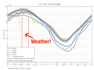
“Another Arctic Sea Ice Milestone“. Anthony Watts is trying to milk the Arctic Sea Ice Extent blip (aka “weather”) for as long as possible. Of course this is only possible with the Nansen Environmental and Remote Sensing Center’s NORSEX estimate, which uses a slightly broader definition of sea ice. Anthony tells us about a sensational “milestone”:
Today it is encouraging to see the NANSEN is reporting that both Arctic Sea Ice area and extent are above the normal line.
What’s actually happening is that the 2010 sea ice extent has tracked previous “low” years until an early March cold snap in the Bering Sea delayed the onset of retreat. After that delay, it’s right back on the same trajectory.
But keep sayin’ it, Anthony.
2010/04/30 Update: Good sea ice info from Dr. Ron Lindsay at the University of Washington has been pointed out in the comments:


Only next September’s sea ice extent results will convince our thin-ice friends on the other side.
These leftovers are only slightly off-topic. From Ron Lindsay’s Web Page:
(beyond difficulties of predicting air temperature, cloud cover, winds) “what we do know is that the reduced ice thickness of recent years will lead to much more variability in the fall ice area and extent because the open water created during the summer is more sensitive to the initial ice conditions and the amount of melt.”
It is interesting to see from his Recap of the 2009 Prediction Season which predictors were more successful:
And which less so:
[Recap of the 2009 Prediction Season. Good info. – Ben]